Kingwood Underground
the heart and soul of our Kingwood, Texas family
Login - Create Account - Help
Clean out your garage on Kingwood bookoo! Or find local garage sales on Yard Sale Search.com
KU Live!

Forest Cove is flooding right now.

who's talking here?

XCPuff 1
Eliza2 1
Porter Wagoner 1
FANCY PANTS 1
RedMulch 1
*LOL* 1
Joe Blow 2
TinktheSprite 2
FXR2 1
queenofclean 2
KingOfSomewhereHot 1
DVaz 7
Judas 1
Sierra22tx 1
Butterbean 9
Leila 1

     » send to friend     » save in my favorites     » flag dangerous topic flag as a dangerous topic

XCPuff --- 10 years ago -

If you know anyone by the golf course especially, houses already have water to door steps.

Laurel Springs off Hamblem has 2 feet of water on the road. 

Joe Blow --- 10 years ago -

It was bound to happen. The ground is saturated. 

DVaz --- 10 years ago -

In 1994 it was 20 to 30 feet deep on Hamblen... 

RedMulch --- 10 years ago -

I have heard about that flood. I don't think it was about rain, I think it was about the idiot floodgate keepers in Conroe. just sayin 

Butterbean --- 10 years ago -

It was a combination of rain and floodgates.

The river authorities are required to open the gates to prevent the dam from breaching.

23-26 inches of rain, if I remember correctly, in about 48 hours or a little longer, mostly in the watershed of the Sanjac. 

Eliza2 --- 10 years ago -

Butterbean is right. We got a bunch on Friday and then they let the dams open up river then that Monday we got 21inches at our house. 

Butterbean --- 10 years ago -

Pretty good document:

1994 Houston flood 

*LOL* --- 10 years ago -

I hope all of our neighbors will be ok- 

FXR2 --- 10 years ago -

Good article about 1994.
I heard that when water was coming in to George Foreman's house in Foster's Mill, that's when Conroe starting tapering down the flow. Who knows?

The bridges we have now on US59/I-69 were not there then. The water didn't go over the bridge pavement but it went over the road on each side of the bridge so they were closed. The only way to town was to go to Conroe and take I-45. 

Joe Blow --- 10 years ago -

How high did the water go in Forest Cove? 

Butterbean --- 10 years ago -

The building on stilts across Hamblin Road from Jacks Grocery had water up to the upper deck.

The Jack's Grocery strip was up to the roof. Every house from there to the river (except those on stilts) had water up to the roof/above first floor.

(edit)That's generally the high water mark. Houses above that level were OK. Those below flooded. 

Butterbean --- 10 years ago -

Another interesting document:


!994 flood


Look at picture #23 and #28 for the 59/Sanjac crossing. Several pictures of the Kingwood/Humble area. 

Sierra22tx --- 10 years ago -

Water to the roof of Jacks in 94 would be 8 to 10 ft not 23 ft on Hamblen Rd as stated earlier. What are you smoking? 

DVaz --- 10 years ago -

The townhouses were completely under water. The two story ones they tore down. That's 20+ feet. It was up to the power lines! 

DVaz --- 10 years ago -

How high did the water go in Forest Cove??

Depends how close to the river. Hell, Kingwood High School had water. A few feet I believe. 

Butterbean --- 10 years ago -

Picture #28 in the last document is of the townhouses by the river edge in FC. You can compare it to present day Google Earth images.

Jacks grocery strip center would be behind the trees in the upper left hand corner. 

DVaz --- 10 years ago -

The water got higher than that photo when it washed away some of the 3-story town homes. Down by Deer Ridge Estates it got higher. My friends in North Shore had to be boated out. They said they had to watch out to not hit the power lines. 

Butterbean --- 10 years ago -

I helped a friend move out of a house below the hill on Redbud. The house is no longer there.

Everyone in Northshore was flooded. I'm reasonably sure the power lines in Northsore were local, not the ones across the river. It's for sure the local lines would be a hazard.

The drainage ditch about 200 yards east of Jacks grocery was used as a boat launching point for recovery operations.

In the picture #29, the oil gathering tanks are on the site they occupy today. They were probably floating in the picture.

It was not a pleasant time. 

FANCY PANTS --- 10 years ago -

Oh please! Forest Cove only flooded in 1994 because Conroe had a problem with their flood gates not operating properly. Forest Cove never flooded before and has not had major flooding since. 

Butterbean --- 10 years ago -

And water always runs uphill. 

Leila --- 10 years ago -

The building on stilts across Hamblin Road from Jacks Grocery had water up to the upper deck.

The Jack's Grocery strip was up to the roof. Every house from there to the river (except those on stilts) had water up to the roof/above first floor.

(edit)That's generally the high water mark. Houses above that level were OK. Those below flooded.


wow! 

Judas --- 10 years ago -

Rain to continue on for at least another week!!! 

DVaz --- 10 years ago -

Even during TS Allison the Forest Cove townhouses only had 2 - 4 feet of water in them. The October 1994 flood was a 500-year flood. Lake Houston bridge was shut down for a week because the water was starting to hit the bridge itself. Woodland Hills Dr was all water from Cedar Falls south across to Atascocita was all water. Kingwood Greens (before it was built) - under water, Kings Harbor, YMCA, etc... all taken over by the combination of Lake Houston & The San Jacinto River. The water came all the way up to Randall's on Kingwood Dr @ WLH!!!

It was epic. 

KingOfSomewhereHot --- 10 years ago -

FANCY PANTS ---
... Forest Cove never flooded before and has not had major flooding since.?


...except in 2001 ... was it TS Allison?... not 23 feet over the road, but a lot of houses with water damage from flooding during that event. (and Hamblen was under a few feet of water) 

DVaz --- 10 years ago -

1994 flood was far worse for actual Kingwood than Allison. All the rain up north used the San Jacinto and Lake Houston as it's dumping stop. At one point the San Jacinto was as high on the old metal 59 bridge flowing over some of it and actually washing part away. Quite a few of the Forest Cove townhouses were just plain washed away. Toys r Us and Best Buy had water inside. Many streets in Forest Cove (off Forest Cove Dr) are still abandoned. Go south past Hamblen and I don't think there is a single one story house left that wasn't gutted and rebuilt. 

TinktheSprite --- 10 years ago -

One of the main culprits for causing flooding problems in Forest Cove are the residents who have not maintained their covered drainage. The cement pipes collapse, debris blocks the flow of water and creates backup and flooding for the rest of the residents. The City maintains the open drains but once covered up it becomes the resident's responsibility. And well, you know how that goes sometimes. 

Butterbean --- 10 years ago -

For those that are interested, Google Earth is a wealth of information.

Look at today's images and compare them to the historic images of 1989. It's real easy to see what was and what is now. 

Porter Wagoner (Mod) --- 10 years ago -

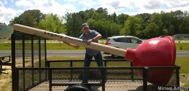
Forest Cove needs one of these:


0 

queenofclean --- 10 years ago -

We have lived in forest cove for 17 years and our ditches have been "maintained" by the city one time, 14 years ago. The ditches on saint Andrews do not drain very well 

queenofclean --- 10 years ago -

We have lived in forest cove for 17 years and our ditches have been "maintained" by the city one time, 14 years ago. The ditches on saint Andrews do not drain very well 

DVaz --- 10 years ago -

historic images of 1989.

Where can I find these old images? I used to have a bunch but they got burned in a house fire. 

TinktheSprite --- 10 years ago -

Call the City, Queen of Clean. You will be put on a list to have your drain dredged. Of course it will tear up your lawn in the ditch. Yes, I know all about St. Andrew's St. There is Caution tape erected by the City at one house a few months ago. Their drain pipes have collapsed making that area of the street flood. His other neighbor's enclosed drains have collapsed, too. It's not the City's problem the homeowner has to pay to repair it. 

Butterbean --- 10 years ago -

Where can I find these old images? I used to have a bunch but they got burned in a house fire.

Open Google Earth, look at the task bar at the top of the screen. The icon to the left of the little sun icon is a historical imagery feature.

You can view map data as it was for several previous years. Use the slider to select the year. Some go back a looooong way. 

page 1
Login to add your comments!

see more discussions about...


Online now:
hit counters

Terms of Service - Privacy Policy - Ice Box

Kingwood Underground